

 Links
Links
Runway Information
Runway 10/28
|
Dimensions: |
5189 x 100 ft. / 1582 x 30 m |
|
|
Surface: |
asphalt, re-paved/grooved 08/2016 |
|
|
Weight bearing capacity: |
Single wheel: 30.0 |
|
|
Runway edge lights: |
high intensity |
|
|
Runway edge markings: |
None |
|
|
RUNWAY 10 |
RUNWAY 28 |
|
|
Latitude: |
40-52.490582N |
40-52.490543N |
|
Longitude: |
081-53.858338W |
081-52.732608W |
|
Elevation: |
1112.1 ft. |
1135.7 ft. |
|
Gradient: |
0.6% |
0.6% |
|
Traffic pattern: |
left | left |
|
Runway heading: |
097 magnetic, 090 true |
277 magnetic, 270 true |
|
Displaced threshold: |
no |
218 ft. |
|
Markings: |
nonprecision, New |
nonprecision, New |
|
Visual slope indicator: |
4-light PAPI on left (3.04 degrees glide path) |
4-box VASI on right (3.00 degrees glide path) |
|
Runway end identifier lights: |
yes | yes |
|
Touchdown point: |
yes, no lights |
yes, no lights |
|
Obstructions: |
89 ft. trees, 2456 ft. from runway, 350 ft. right of centerline, 25:1 slope to clear |
5 ft. road, 201 ft. from runway |
Airport Services
|
Fuel available: |
100LL JET-A1+ |
|
Parking: |
hangars and tiedowns |
|
Airframe service: |
MAJOR |
|
Powerplant service: |
MAJOR |
|
Bottled oxygen: |
LOW |
Location
|
FAA Identifier: |
BJJ |
|
Lat/Long: |
40-52-29.4000N / 081-53-17.7000W |
|
Elevation: |
1135.8 ft. / 346.2 m (surveyed) |
|
Variation: |
07W (2000) |
|
From city: |
6 miles NE of WOOSTER, OH |
|
Time zone: |
UTC -5 (UTC -4 during Daylight Saving Time) |
|
Zip code: |
44677 |
Airport Operations
|
Airport use: |
Open to the public |
|
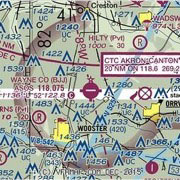
Sectional chart: |
DETROIT |
|
Control tower: |
no |
|
ARTCC: |
CLEVELAND CENTER |
|
FSS: |
CLEVELAND FLIGHT SERVICE STATION |
|
NOTAMs facility: |
BJJ (NOTAM-D service available) |
|
Attendance: |
MON - FRI 0700-1800 SAT - SUN 0800 - 1800 |
|
Wind indicator: |
lighted |
|
Segmented circle: |
yes |
|
Lights: |
HIRL RY 10/28 PRESET LOW INTST DUSK TO DAWN ; |
|
Beacon: |
white-green (lighted land airport) |
Airport Communications
|
CTAF/UNICOM: |
122.975 |
|
WX ASOS: |
118.075 |
|
AKRON-CANTON APPROACH: |
118.6 |
|
AKRON-CANTON DEPARTURE: |
118.6 |
|
CLEARANCE DELIVERY: |
121.75 |
| • APCH/DEP SVC PRVDD BY CLEVELAND ARTCC ON FREQS 134.9/317.7 (MANSFIELD RCAG) WHEN AKRON-CANTON APCH CTL CLSD. | |
Nearby radio navigation aids
|
VOR radial/ distance |
VOR name |
Freq | Var |
|
BSVr295/22.2 |
BRIGGS VOR/DME |
112.40 | 04W |
|
TVTr026/27.3 |
TIVERTON VOR/DME |
116.50 | 03W |
|
DJBr162/31.5 |
DRYER VOR/DME |
113.60 | 05W |
|
MFDr092/31.9 |
MANSFIELD VORTAC |
108.80 | 03W |
|
ACOr250/34.1 |
AKRON VOR/DME |
114.40 | 04W |
|
NDB Name |
Hdg/Dist | Freq | Var | ID | |
| ASHLAND |
115/17.4 |
329 | 07W | AAU |
.- |
Instrument Procedures
NOTE: All procedures below are presented as PDF files. If you need a reader for these files, you should download the free Adobe Reader.
NOT FOR NAVIGATION. Please procure official charts for flight.
FAA instrument procedures published for use between 10 December 2015 at 0901Z and 7 January 2016 at 0900Z.
IAPs - Instrument Approach Procedures
RNAV (GPS) RWY 10 RNAV (GPS) RWY 28 VOR RWY 10
VOR RWY 28
NOTE: Special Alternate Minimums apply
NOTE: Special Take-Off Minimums/Departure Procedures apply
Other nearby airports with instrument procedures: